Strong Storms Headed For The Quad Cities Monday Afternoon
The National Weather Service is warning of decent chances that there will be strong storms moving into the Quad City Area this afternoon - with high winds, hail, and possibly even tornadoes.
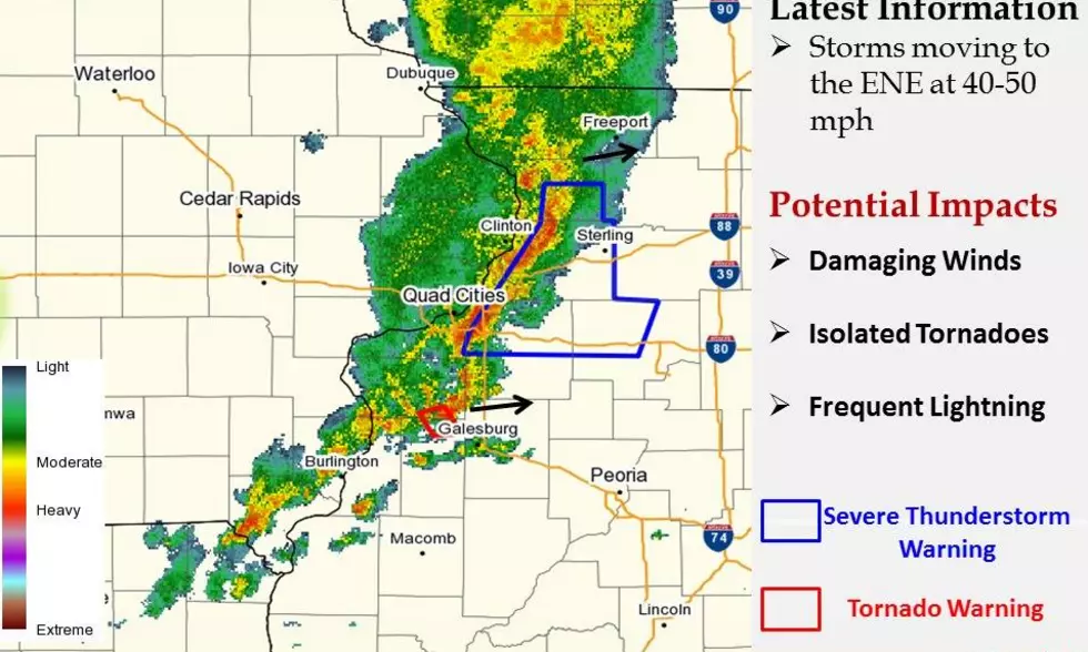
According to the statement issued by the National Weather Service, "Thunderstorms will develop along a cold front across portions of the Outlook Area today. Some storms will be strong to severe. Where they form is still somewhat uncertain, but current indications suggest they will develop across areas along and north of the Interstate 80 corridor by midday, and then they will spread eastward and southward during the afternoon into evening."
If you're looking to keep your car safe, might be a good idea to move it into the garage, since we all can remember the 2020 hailstorm that damaged homes, businesses and vehicles.
"The primary threat from severe storms will be damaging winds, with secondary risks of large hail and isolated tornadoes," National Weather Service said. "The storms will also be able to produce heavy rainfall at high rates, which may induce some localized flooding in areas that get hit by several storms."
This map shows the forecast for Severe Weather just east of the QCA around 5pm, as it moves through the area.
Along with the strong storms, be ready for some heat as well. The service says very warm temperatures and humidity will bring us temperatures as high as the upper 90s in the area this afternoon.

LOOK: Here are the 50 best beach towns in America
Gallery Credit: Keri Wiginton
More From Rockford's New Country Q98.5